The Red River Gorge Geological Area
The Red River Gorge Geological Area attracts thousands of outdoor recreation enthusiasts year round. Sculpted by wind and water over millions of years, the gorge is carved out by these powerful forces of nature. Towering cliffs line the upper slopes of forested ridges. Unique rock features, including sandstone arches, appear on the landscape as natural monuments. Beneath the ridges, boulder strewn creeks and streams flow through the gorge in densely shaded coves of hemlock trees and rhododendron. Rock climbers, hikers, canoeists and campers are just a few who come to explore the gorge.
More than 100 natural sandstone arches can be found in the Red River Gorge and nearly 70 miles of trails. Many trails are considered strenuous so hikers should consider physical ability before choosing a trail to hike. Area maps do give the length of the hike to be able to plan your time. A good rule of thumb is to plan approximately 35-45 minute per mile of hiking time for the casual hiker in this terrain. Sky Bridge and Grays Arch provide picnic areas, restrooms, great scenery and trails. All official trails have a name, number and are marked with white diamonds painted on trees. If you are unfamiliar with the area please stick to the designated trails only as they are maintained.
One of the most interesting features of the “Gorge” is the Nada Tunnel, a 900 ft tunnel along Rt. 77. Built in the early 1900’s, this one lane tunnel once provided railroad transport of timber from the Gorge.
| RRG Hiking Map.pdf |
Gladie Cultural-Environmental Learning Center
The Gladie Center is located in the unique Red River Gorge. Here, you can learn about the cultural heritage, unique resources and spectacular geology found within the boundaries of the Red River Gorge Geological Area and Clifty Wilderness. The Gladie Center contains interpretive exhibits that provide a glimpse into the past and convey the wild, natural beauty that visitors seek today when entering the Gorge. Trail, camping and other information is available at the center. Available for purchase are maps and passes. Directions: From I-64, take exit 98 to the Bert T. Combs Mountain Parkway. From the parkway, take exit 33 (Slade) and turn left onto KY 11. To access Gladie through Nada Tunnel, turn left onto KY 15 and travel 1.5 miles west to KY 77. Follow 77 to KY 715 and turn right. Stay on 715 and follow the signs to Gladie.From I-64, take exit 98 to the Bert T. Combs Mountain Parkway. From the parkway, take exit 33 (Slade) and turn left onto KY 11. To access Gladie through Nada Tunnel, turn left onto KY 15 and travel 1.5 miles west to KY 77. Follow 77 to KY 715 and turn right. Stay on 715 and follow the signs to Gladie. Call: 606.663.8100
Sheltowee Trace National Recreation Trail

|
This is a 290 mile trail from northern Kentucky to Pickett State Park, Tennessee. Sheltowee, meaning Big Turtle, was the Shawnee name given to Daniel Boone who explored the land in this region. This trail is commonly used by overnight back packers and connects to other trail systems. The section of this trail will have a turtle imprint painted on a tree to designate the Sheltowee National Trail. This trail is maintained by the Sheltowee Trace Association. For more hiking in the Gorge click HERE.
|
Camping in the Geological Area
Backcountry camping permits are required for those who wish to stay in the Red River Gorge overnight. They are sold at many area gas stations and convenience stores and must be displayed in any vehicle that is parked within the Red River Gorge between the hours of 10pm and 6am. Permits Cost $3 for a day, $5 for three days or $30 for an annual pass. Click HERE for popular backcountry camping locations. Everyone who wishes to see the natural beauty of the Red River Gorge, KY should practice the principles of Leave No Trace. It is very simple actually; if you pack it in then pack it out. We want all visitors to leave the area as they found it so the Red River Gorge can be enjoyed in its natural beauty for years to come.
Backcountry camping regulations are as follows:
Backcountry camping regulations are as follows:
- Food Storage Restriction due to black bears. Dispersed campers must hang food and garbage at least 10 feet off the ground and 4 feet away from any tree or post used for suspension.
- No camping in rock shelters. Camping and campfires are prohibited within 100 feet from the base of any cliff or rock shelter. Dispersed campers must be 300 feet away from any road, trail or stream and 600 feet away from Grays Arch. Watch for areas posted "No Camping."
- No rockclimbing or rappelling within 300 feet of Sky Bridge, Grays Arch, Nada Tunnel or Chimney Rock overlook. Any new climbing routes must be approved.
- Geological Area: No motorized vehicles on any trail. Horses are permitted only in designated areas.
- Cliffty Wilderness: No motorized or mechanized equipment. Trails are open to hiking only
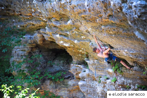
Rock Climbing
|
Rock Climbing is permitted in the Gorge, but new route development is not allowed without authorization. This area is under the management of the US Forestry Service so be aware of the rules for wilderness camping and Leave-No-Trace. There are too many climbing locations though out the Red River Gorge to speak about so visit the Rock Climbing page for a breakdown of the most popular locations.
Be sure to check out the online Climber's Guide book for the list of all the routes in all the locations of the Red River Gorge. You can also visit www.redrivergorgeclimbing.com which list the most popular climbing locations on private lands in the Southern Region such as Muir Valley and Pendergrass Murray Preserve. The best printed source of information on rock climbing in the Gorge is a book “Red River Gorge Rock Climbs” by Ray Ellington.
|